THE wool hat!

 The Brun family gets wooly.... With real wool hats from Peru!
posted by z-rat at 6:31 PM
1 comments
![]()
A first hand account of Michelle Blank's and Alex Brun's outdoor expedition to Ecuador and Peru. The expedition objectives are to trek, travel, climb, eat, photograph, eat some more, laugh, eat, etc.
The Brun family gets wooly.... With real wool hats from Peru!
posted by z-rat at 6:31 PM
1 comments
![]()
 Here we are after a succesful flight to Houston from Quito. Notice the matching t-shirts, a sure sign of of a successful trip! (The mountains on the shirts are the highest volcanos in Ecuador!) Don't laugh please, we are very serious about our matching t-shirts.
 Here is a view of the Illizinas mountains from the 757. The mountain on the left is Illizina Norte, a climb we attempted about two weeks ago, but turned around due to poor weather. I got a kick seeing it from the airplane window and a good parting view of Ecuador.
posted by z-rat at 8:55 PM
1 comments
![]()
 It is our last day in Quito, which means some major packing up and baggage rearranging. It's amazing to see how much stuff we've been packing around this country. Tommorrow we'll be leaving for the airport at 4:30am. With some luck we'll make it back to Portland and Boise in time for Christmas!
 Michelle says: ¨I will crush these little crampons to dust with the strength of my fingers. Hurry up and finish packing everything up Alex or I will do the same to you!¨
 Before returning to Quito, we made a trip to Lake Cuichocha, Ecuador´s most scenic lake (according to the guidebook). It was actually really overcast on our visit, so not wanting everyone to miss out, I took this photo of the what the lake and the mountain (cotchachi) look like in good weather (a rare occurence) in the visitor center.
 Here is a view of the lake on the day we visited. The lake was formed when the crater of a volcano collapsed. The two islands, barely visible in this photo, were formed by a flare up of volcanic activity. The islands resemble cuy, guinea pigs, hence the name cuicocha.
 The park is home to many types of flower and fauna including the rare condor and oso de anteojos, bear of eyeglasses. There were numerous orchids and other beautiful wildflowers.
 Here the lake is submerged by the fog that kept creeping over the southern ridge.
 After the attempt on Chimborazo we spent of few days resting in Quito and then bussed it to Otavalo. Otavalo is a small town just north of Quito known for its artesian market. The success of the market has resulted in an affluent city. Here is a church on the far side of a pretty plaza.
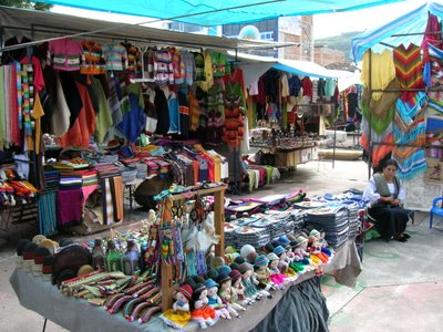 The Otavalo market. During the week the market is limited to a plaza in Otavalo. On saturday it takes over the entire city. Small communities outside Otavalo specialize in producing various items including leather, weavings, and paintings. They bring these items to market in Otavalo to sell. Indigenous communities around Otavalo are some of the most affluent in the country due to the success of the market and tourism.
  School girls march in a parade in Otavalo. Festivies like these take place throughout the country in anticipation of Christmas. Often the parades include dancing and music.
posted by z-rat at 2:13 PM
1 comments
![]()
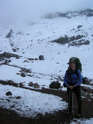
 Chimborazo is the highest mountain in Ecuador. The equatorial bulge means that the summit of Chimborazo is the closest you can be to the sun while on earth, closer even than Mount Everest! Chimborazo can be a challenging climb depending on the conditons, if it hasn't snowed recently, the ridge to the summit can actually be low grade ice climbing! Fortunately there had been a lot of snow, so we thought we'de do some exploring. We stayed at the refugio, a measely 16,400 ft.
 The mountain was covered in clouds until just before sunset. Here the fog rolls away to reveal a brief glimpse of sunlight. We've discovered that the mountains tend to be cloudy from mid-morning until late evening. Nights and early morning are often crystal clear.
 Our expersions reveal our moods perfetly. Alex: excitement. Michelle: near hysterical anticipation.
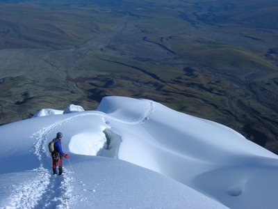
 We started the climb with the four other guided groups at 12:15, walking up a snow covered moraine, then winding our way through large rock terraces and around these peculiar ice tables.
At 18,000ft a funny thing happened, Alex started walking like he was intoxicated: alitude sickness was starting to show. We had just gained the promient ridge, which leads to the summit. Michelle by the way, was kicking butt at this altitude, virtually pulling me up the hill. Not liking the idea of trying to descend all the way from the summit, being out of balance and exhausted, we turned around. Two hours later we were followed by the other guided groups due to bad avalanche conditions above.
 We were back to refugio by 4:30 am and Alex tried to sleep off the searing headache. No luck. He didn't start to feel better until we were driving toward Riobamba.
 Michelle on the descent back to the trailhead. She was so full of energy that she actually carried Alex on her back. Descending from the refugio to the road you pass through a graveyard with memorials to climbers who have died on Chimborazo. Pretty sombering. We were back in Riobamba by lunch time and on a bus to Quito within an hour. Only in Ecuador can you get to and from 20,000ft peaks so easily.
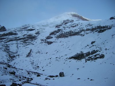 One last look at the mountains (because we haven't figured out how to erase photos).
posted by z-rat at 5:52 PM
2 comments
![]()
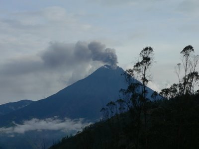 After Cotopaxi, we headed south on the Panamerica to the small city of Riobamba and then on to one of Ecuador´s top five tourist spots, Banos, for some serious relaxing. A small town perched directly under this extremely active volcano. We even heard it rumble once as it belched ash and steam! In 1996 the town was evacuated, but when the volcano failed to errupt the government let people return to their homes. In August of this year the volcano spit lava, which caused a mudslide wiping out a section of the road to Banos! But according to our taxi driver, after seven years of living beneath the belching volcano, he wasn´t particularly afraid of an impending erruption.
 Alex looks suave on his smooth rider. One of the big tourist activies is to bike from Banos toward the jungle. The road runs alongside the Rio Pastaza, which is fed by spectacular waterfalls. It reminded us of the waterfalls that can be seen from Highway 20 during early summer in the North Cascades.
 Another popular tourist activity is bridge swinging. Like bungy jumping, except the rope is ridged in such a way that you swing rather than fall. Neither Alex nor I wanted to give it a try. Here we are watching another adventurous (dumb?) young tourist.
 The bike route passes by the access point for Pailon del Diablo, the most famous waterfall in Ecuador. Michelle ventures down a slick stairway to the vista point.
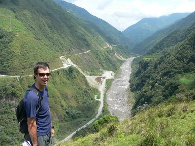 The following day we explored the Rio Pastaza from the opposite side, following a trail that winds past citrus orchards, occasional mud houses, orchids, grasslands, and even a schoolhouse. Crazy to think that people living on this side of the river can only get their goods to market by carrying them along the path or taking the taribita across the river (no cars, no moterized equipment).
 Michelle crosses the river in the taribita. The cable car was about a 1,000 ft above the river and motored speedily from one side to the other.
 Banos is known for a particular type of taffy, which the venders pull and stretch when the candy is still warm to get it to the right consistency. We tried it both hot, straight from the doorknob, and cold after it had been flavored and packaged.
posted by z-rat at 5:49 PM
0 comments
![]()
 Before leaving Hosteria PapaGayo, we arranged for a short horseback tour. It turned out be a great time. A minimal amount of time was spent actually learning how to ride, and soon we hit the cobblestone streets with our guide Luis, who has taught all of the horses how to march! I was a little bit nervous when Luis was teaching us how to ride the horses because all the lessons were in spanish. Fortunately, my horse just happily followed along and I enjoyed the view.
 Well this was taken from a moving horse, so the picture is a little crooked. But suffice to say Michelle is a real gaucho, especially with that cowboy hat (climbing helmet). Her horse really enjoyed eating grass. We both walked like cowboys after our time in the saddle.
posted by z-rat at 4:48 PM
0 comments
![]()
 Hitchiking on the Panamerica highway to get to the entrance of Cotopaxi National Park and then we hired a truck to get to the refugio. Pretty exciting to be hitchiking with an ice axe and crampons.
 Our best view of Cotopaxi, it was always covered in clouds.
 Michelle on the 35min hike from the trailhead to the Refugio at 15,750ft. After about a week of acclimitization, it actually wasn´t too hard of a hike, we were surprised to find out.
 Jose Rivas Refuge. A nice little place with two wood stoves to keep it warm. Unfortunately the place was packed with groups of guided climbers (we were the only independent climbers!), consequently we didn't sleep much the evening before the climb.
 Starting the climb at 1:00 am, Alex kicks steps in the frozen snow.
 This photo was taken at 1:10am and 16,000ft when the whole climb still seemed like fun! Notice the smile, it wasn´t there at 18,000ft. Seriously, we were pretty excited and moved fast to show the guides what we were made of. We even led the way for awhile, then we realized that was stupid and let the guides kick all the steps! Thanks guys!
 At 19,250 ft, Alex struggles towards the summit. After we finished the climb, a guide told me that if we wanted to climb Chimborazo (Ecuador's highest peak at 20,000 ft) Alex needed to be in better shape! Check out that face. From about 18,000 ft on we walked five steps and stopped to pant a while. It was like breathing through a straw. We almost turned around at this point, due to really cold feet (leather boots at altitude aren´t all that great), but pushed on anyway.
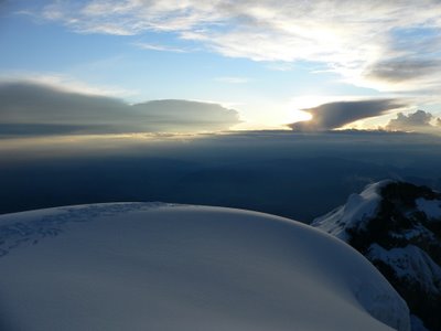 The sunrise at 19,350ft. We reached the summitt at 6:00am, five hours after leaving the hut, and were rewarded with a great view.
 Alex celebrates! Take that you lousy guide.
 Quite possibly the nerdiest photo of Michelle on the internet, but when you have just climbed Cotopaxi, you really don´t care about much, except getting down where its warmer and there is more air. We were cold and wasted by this point, and I´m not sure why that climbing rope is around my neck like a giant´s necklace.
 The descent. After fighting past several groups coming up, we seriously began plunge stepping back to the refugio.
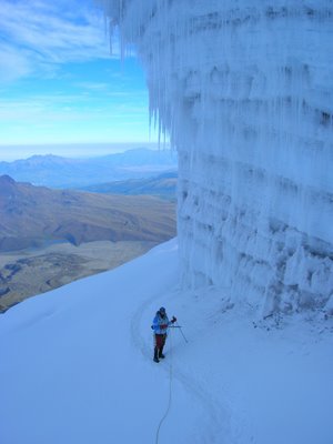 Michelle, after descending a thousand feet or so felt alot better, and ice climbed up this giant ice formation. Pretty impressive, huh? Actually, we were making our way very slowly down and getting passed by the guides who were short roping their clients down steep snow slopes at reckless speeds.
 Alex enjoys a last clear look at Cotopaxi, reflecting on the past eight hours of climbing. We made it safely back exhausted but excited. After sleeping (14 hours straight for Michelle) we are even more excited about the experience.
posted by z-rat at 1:16 PM
5 comments
![]()
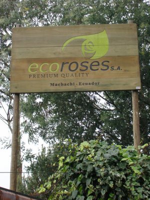 This is Eco Roses, a rose plantation right next door to our Hostel. One of the two largest in the local area, Eco Roses is a major supplier of roses to the US, while proclaiming a more environmentally friendly method of growing roses. It also is better for its workers, according to our guide who used to work there.
 One of the reasons, I wanted to take a tour of the rose farm, is that roses in Ecuador is big business. They grow the roses in the greenhouses that are spread over many acres of land. Each worker is responsible for 40 rows of roses and each row is labeled with the workers name. This particular plantation employs 150 people and each greenhouse (there are 13 greenhouses) have their own soccer team as well!
 The rose growing industry is one that is notorious for extreme pesticide use (to keep the afids away, I´m guessing) Anyhow, our guide, who is now the cook at the hostel, told us that the company now longer allows the workers inside the greenhouse when they are spraying, so I guess that is an improvement. The buckets on the right, are filled with citric acid for preserving the flowers after they are cut.
posted by z-rat at 1:15 PM
1 comments
![]()
 We continued our acclimatization with a trip to Illiniza Norte, a 16,800 ft peak. Alex and I spent the night in the refugio (mountain hut) at 15,250 ft. Michelle and Carly, our new friends, accompanied us to the refugio to play a few games of cards and then headed back down the same day. It was a fun trip to the parking lot, with a skilled driver manuvering around mudholes and a river crossing on the dirt road. Carly, Michelle, and I rode in the back, standing up with the wind in our faces. Please note that the two Michelles are wearing matching shirts.
 A two hour hike from the end of the dirt road, through paramo and up a steep moraine, led us to the hut. Our new friends got this great photo of us struggling up the moraine in the thinning air, just like the book.
 Alex drinks some hot tea outside the brightly painted refugio, with some fresh snow on the ground. The inside of the hut wasn't as well maintained, with mold creeping up the walls, but warmer than outside nonetheless. Both Alex and I had trouble sleeping at 15,250 ft, breathing too fast to sleep normally.
 Illiniza Norte at 16,800ft is a rocky scramble, until the last 500ft, where it becomes more exposed and a little harder. Unfortunately, the typical afternoon storm deposited just enough snow on the rock to make the climb out of condition for us. We felt better, when we learned that the guided groups also decided to turn back as well.
posted by z-rat at 1:13 PM
1 comments
![]()
